Home Page | Map and Climate | Sunshine Studies | Sequim Weather | Sequim Webcam | Activities | About
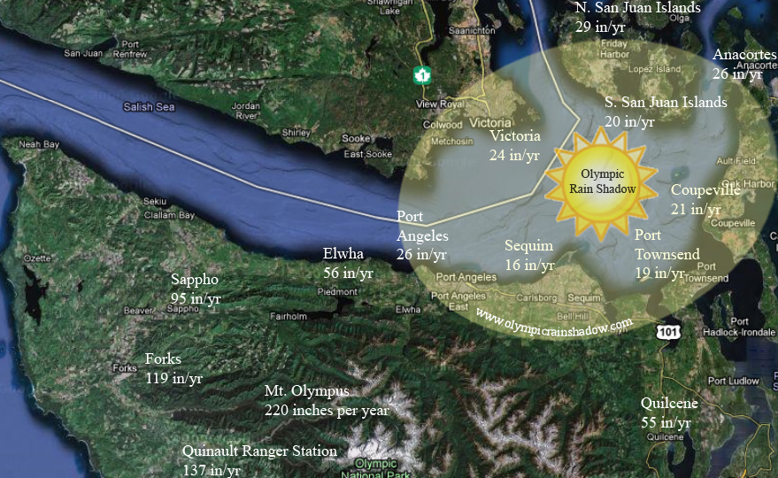
The Olympic Rain Shadow is roughly elliptical in shape and lies along a SW to NE axis from the town of Sequim to the town of Anacortes; our estimate of the location is depicted in the Olympic rain shadow map lower on this page. The table to the right summarizes of average annual rainfall in areas around the rain shadow, and illustrates the dramatic differences that occur in short distances. For example, as you head due west from Port Angeles on highway 101 to the small town of Elwha, the annual precipitation increases from 26 inches to 56 inches in at mater of 10 miles; continuing west, the annual precipitation increases from 56 inches to 95 inches in Sappho in the next 27 miles. These towns are all roughly at the same elevation. The ranger station of Quinault in the SW foothills of the mountains receives 137.21 inches of rain, and Mt Olympus itself receives roughly 220 inches of rain a year, while locations within the rain shadow receive on average only about 20 inches of rain per year. But precipitation is only one way to locate the rain shadow. For some people, the number of sunny days per month, the average temperature on their back deck, or the growing season for vegetables might be equally important. Unfortunately, climate data of this type is either not available or hard to find. That is one of the reasons we installed an advanced weather station with solar radiation sensors close to the center of the rain shadow. As time permits, we will investigate the climate in other rain shadow locations, but as a start, we've published our rain shadow sunshine study which compares sunny days in and out of the rain shadow during October 2010. Informal investigation of satellite photos, vegetation patterns, and sage observation indicate the rain shadow area to be bordered by and �defined� by the "anchor towns of Sequim, Port Townsend, Coupeville, and Victoria, BC but also including much of western Whidbey Island and the Southern San Juan Islands. All of these locations receive 25 inches of rain or less per year. The �epicenter� of the rain shadow is a matter of debate, but it is likely somewhere to the north east of the town of Sequim, and only receives about 13� of rain per year, about the same as relatively dry cities like Los Angeles, or Salt Lake City. Our best estimate of the rain shadow area is depicted by the map below. Olympic Rain Shadow Map
Climate Overall the climate in rain shadow areas is relatively sunny, windy, and cool. Spring arrives early and lasts long. We notice distinct changes in the month of February; usually we mow the lawn twice during this month, and there are significant stretches of clear weather. By the arrival of months more typically associated with spring, say April, mornings are often in the 40's and clear, and afternoons can easily be in the mid 50's. Sunny stretches and beautiful, partly sunny days are common, with stormy periods frequent, but usually brief, a day or two at a time. Overcast, gray weather is possible, but not common. By early summer, for example Memorial day, the length of the day, and increased sunshine have often already started to dry out the lawns, but other vegetation is growing in full force. Often we are surprised by a cold and windy storm in late May to late June, dropping new snow on the crest of the Olympics. High summer, which includes July, August, and September, rarely have precipitation at all. There is allot of sun during this period, but it is not hot. High temperatures average in the 70's with some days in 60's and some in the 80's. Evenings and nights are cool, with temperatures in the 50's. The maritime location has a major influence during this period. The first effect is wind. Afternoon wind is quite common, and over the offshore waters of eastern strait it is often very strong. The next maritime influence is occasional AM fog, or late AM clouds. The days seem to come in three varieties: clear all day; clear sunrise with some clouds late morning followed by sun; and maritime fog till mid morning, then clear onward. Fall is a relatively brief transitional period in October and part of November, with variable weather. Usually there will be a brief cold storm in early to mid October, which delivers the first blanket of snow to the higher Olympic mountains, followed by a clear night or two with temperatures close to freezing. Winter includes late November, December, and January in rain shadow areas. The sun is lower in the horizon, and storms are common, but periods of sunshine are common too. There are frequent crisp clear periods following the storms, and sometimes sunny periods during extended periods of high pressure in January. Storms can be very strong and windy in this period. There can also be periods of gray weather which can go on for multiple days at this time of year. This seems to happen during times with multiple weaker storms with less defined fronts. Snow and cold periods also arrive, more frequently than in the greater Seattle area, perhaps once or twice a year. But as most areas are right at sea level, the sun or a warmer storm usually melts things off in a day or so.
Meterology The unique microclimate and weather in rainshadow areas is due to the rain shadow effect and the nearby olympic mountains. To understand this in detail, see our olympic rainshadow effect page.
Additional Resources There are a variety of additional online resources for learning more about the rainshadow.
|
|
Home Page | Map and Climate | Sunshine Studies | Sequim Weather | Sequim Webcam | Activities | About |