|
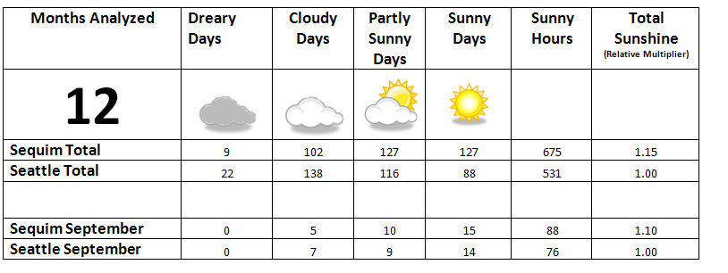
Home Page | Location and Climate | Sunshine Studies | Meteorology | Sequim Weather | Sequim Webcam | Resources | Blog | Photo Gallery | About The following table summarizes Sequim sunny days vs. Seattle sunny days, in Washington state, starting in October 2010.
See our Summary page of all monthly reports to view monthly climate summaries with daily sunshine data, and study methodologies.
These studies were conducted by examining incident
solar radiation. Solar radiation is measured in watts per square meter. This
measurement is directly related to illuminance, a measure of how much light
falls on a given area. We used data from three different weather stations.
The second location is in downtown Port Angeles, at Lincoln High School. The school's Davis Instruments Vantage Pro2 Plus sensors are mounted on the rooftop of the high school, about a mile southwest of ferry dock to Victoria B.C. at an elevation about 200 feet. There is excellent exposure clockwise from northeast to southwest and good exposure for the other directions. The sensors record solar radiation every five minutes. Special thanks to Peter Alexander, his math classes, and Lincoln High School for the data and support.. The third location is atop the Atmospheric Sciences Department building of the University of Washington, in the University District of Seattle. This seven story building is not in the classical Olympic Rain Shadow area, but is still slightly shadowed by the Olympics. Given that the sensor is located atop a tall building, this location has ideal exposure and receives maximum solar radiation. This station records solar radiation every minute. Data was retrieved by downloading public information from the University of Washington’s Department of Atmospheric Sciences website.
Data was aggregated, analyzed, and graphed using Microsoft Excel. |
|
|